skip to main |
skip to sidebar
In the Jaffna Peninsula, on the island of Nainativu is situated the Nagadipa Vihara, one of the 16 sacred places of worship in Sri Lanka. According to the chronicles, in the 5th year after enlightenment,Lord Buddha visited Nagadipa to settle a dispute between two  Nàga Kings - Chulodara and Mahodara regarding a gem throne. The Bak Full Moon Poya commemorates Buddha's visit to Nagadipa to settle a dispute between Chulodara and Mahodara, two kings belonging to the Naga tribe, over the possession of a gem studded throne.
  It was a battle between uncle and nephew - the uncle being Mahodara and Chulodara, the nephew. Mahodara's sister had married another Naga king and Chulodara was their son. After the death of Chulodara's grandfather the gem studded throne which belonged to him was given to the daughter, Chulodara's mother.
Mahodara wanted to take possession of it. When Buddha came over from Jetavanarama in the city of Sravasti, He was accompanied by God Sumana , a protective deity residing on a tree at the entrance to the Vihara.
 According to legend, he was a resident of Nagadipa in his previous birth and had provided some Pacceka Buddhas with leaves from a tree to clean their alms bowls. The merit he acquired from that deed had made him a deity.
The Buddha preached the virtues of non-violence to the warring factions. He urged them to forget hating each other and be united. The two kings surrounded by their followers listened patiently to the Buddha and decided to end their enmity.After the two warring kings made peace the throne was offered to the Buddha, who returned it to the Naga kings. It was later enshrined in the Nagadipa Stupa and soon became a place of Buddhist veneration.
There have been instances when Nagadipa and Ruhuna which were at times ruled by members of the royal family, were at other times administered by 'amatyas' or courtiers.Nagadipa later came to be referred to as Nainativu island. Until the escalation of the northern war, Nagadipa was a popular place of worship with Buddhists from all over the island visiting the sacred place to venerate the spot hallowed by the Buddha.
The open semester to Sri Pada, the holy mountain, began on the 'Unduvap' fullmoon day (Dec. 30) and will end on the 'Vesak' fullmoon day (May 26) in the ensuing year. This mountain is also known as Samantakuta, Sumanakuta, Samanalakanda,  Samanhela, Samangira, Medumh
 elaya etc. The Christians call the mountain Adam's Peak, derived from the Portuguese Pico de Adam (Peak of Adam). This conical mountain is situated 16 km. North-East of Ratnapura, and rises much abruptly from the lower valley than any other mountain in the island. Although it is not the highest mountain, it rises to a trignometrical altitude of 2,243m. (7,360 ft.) above sea level, offering an unobstructed view over land and sea, overlooking the South-central mountain ridges. The splended view of the tropical wilderness, with its hills, dales and plains, all luxuriantly wooded, bounded by blue mountains, fleecy clouds resting on low ground, and a brilliant sky over-head adds to the panorama of the resplendent island. The charms of the prospects are heightened by the coolness and freshness of the air, and by animation of the scene produced by the singing of birds, in addition to the harsh cries of the wild peacock and the jungle fowl. From remote antiquity, the visibility of the conical mountain from vessels off-shore to a distance of about 15 km, excited great interest of foreigners, when the island's interior was unknown to the outside world. It was also the landmark of the sea-faring Arabs, Moors, Greeks and Persians, who came to the island to barter in gems, ivory, spices, elephants etc.
Footmark
The sacred footmark atop the mountain (as most of us have seen) is a superficial hollow of gigantic size, measuring 156 cm. in length, and 76 cm. towards the toes and 71 cm. towards the heel in width. There is the belief that the actual footmark lies on a blue sapphire beneath the huge boulder upon the summit, and what we see is only an enlarged symbolic presentation. The placement of such a huge boulder is attributed to god Visvakarma, who had done so for purpose of protection. The summit is a small plateau, having an area of 164 sq.m., or 1,776 sq.ft. (74 X 24 ft.), according to measurement taken by Lieut. Malcolm of the British Rifle Regiment, the first European to ascend the mountain in 1816. He had signalled his arrival at the summit by firing three cannon shots from his swivel musket, into the valley below. The sacred footmark as seen by Dr. John Davy in 1817, was ornamented with a single margin of brass and studded with a few gems. These are now not to be seen. He says, "The cavity of the footmark certainly bears a coarse resemblance to the figure of a human foot but much oversized. Whether it is really an impression is not very flattering, if not for its huge size. There are little raised partitions to represent the interstices between the toes, to make it appear a human foot." Robert Knox, the European captive, who spent 20 years (1660-1679), in the Kandyan kingdom, says "The Mountain is at the South end of the Country called Hammalella (Samanhela), but by the Christian People, Adam's Peak, the highest in the whole island, where, as has been said, is the Print of the Buddou's foot, which he left on the top of that Mountain in a Rock, from whence he ascended to Heaven. Unto this footstep they give worship, light up Lamps and offer Sacrifices, laying them upon it, as upon a Altar." According to the Mahavamsa, the Great Chronicle of the Island, the first person to ascend the holy mountain Sri Pada, was king Vijayabahu I (1058-1114), having come to know that atop the mountain is seen the footmark of the Buddha. It is said that he had gathered this information from the pious woman Manimekhala, who, as a devout Buddhist, was living in South India. Another version is that the king had seen, in the early hours of one morning, angels plucking flowers in his garden. When questioned, one of them had said "We are plucking flowers to worship the footmark of the Buddha atop the Samanalakanda."
Copper
The Ambagamuwa rock edict and the Panakaduwa copper plate bear witness to the royal patronage extended by king Vijayabahu, by building 'ambalamas' (rest camps) on route for the convenience of the pilgrims, and also provided them with food and water. The king also built a lower 'maluwa' (place of worship) for his Hindu consort Tiloka Sundari to make her benefactions to the Hindu deity Siva alias Iswera. Actual pilgrimage to the mountain began during the reign of Sri Nissankamalla (1187-1196), after he ascended the mountain with his fourfold army with great faith and devotion. There are two historic approaches to the summit of Sri Pada. The oldest is the Ratnapura path, popularly known as the 'difficult path' via Malwala, Kuruwita, Eratna and Gilimale. The last station is Palabaddala. The path runs through ascending and descending hills, deep valleys, along edge of precipices, with a river foaming beneath and, sometimes, under over-hanging rocks and along the beaten track, highly infested with leeches (blood-sucking worms). On this path, pilgrims have to walk long distances until a camp is reached. Half way up the mountain, there is a small torrent that flows over an immense tabular mass of rock, which forms the 'Seetagangula' (stream of icy water), the parent stream of the Kalu-ganga. At this point, the scene is very impressive and the atmosphere calm. The pilgrims stop here for a break to perform their ablutions, while some bathe, some make a frugal repast of rice or bread, some rest themselves before making the steep climb, some chew betel and others chat to break the monotony of the jungle. The itinerant Arab pilgrim Ibn Batuta alias Abu Abdallah Mohammed (1304-1377), and the Venetian traveller Marco Polo (1254-1324), had ventured to reach the summit via the Ratnapura path "to worship the sepulchre of Adam" as they believed the footmark atop the mountain to be that of Adam (the first parent of the human race). From Barberyn (Beruwala), they had followed the Kalu-ganga to the summit.
Path
The other path is the Rajamawatha (now the Hatton path), and it came to be so known because many kings, during and after the Gampola period (1347-1412), had made their way to the mountain through that path. It began from Gangasiripura (now Gampola) via Ambagamuwa, Kehelgamuwa, Ulapangama, Horakada, Dagampitiya, Makulumulla, Hangarapitiya, and by the Laxapana pass to the summit. There is also a 'Seetagangula' on this route which is the parent stream of the Mahaveli-ganga. The Rajamawatha was constructed by the Chief Minister Devapathiraja who served under king Parakramabahu III (1283-1293). Pilgrims travelling by train break journey at Hatton (173 km. from Colombo) on the Main Line, and continue by bus to Maskeliya and thence to the Delhousie Bazaar, from where all transport facilities cease. A serpentine gravel road leads the way to the Sama Cetiya, en route, where camping is available for cooking food and for resting. The next halt is the 'Seetagangula', where pilgrims get ready to make the ascent. A group of pilgrims is known as a 'nade' and the chief is the 'nade gura' who is supposed to have made many visits to the holy mountain during his lifetime. A newcomer is known as 'kodukaraya' and he or she is at the mercy of the 'nade gura'. Age is no barrier to this novice.
Adam's Peak - Sri Pada of Buddha - Special Thank to Aryadasa Ratnasinghe

 Eight miles east of Anuradhapura, close to the Anuradhapura - Trincomalee Road is situated the "Missaka Pabbata" which is 1000 feet in height and is one of the peaks of a mountainous range. Though this was called Cetiyagiri or Sagiri, it was popularly known as Mihintale - the cradle of Buddhism in Sri Lanka. Thera Mahinda came to Ceylon from India on the Fullmoon Day of the month, a of Poson (June) and met King Devanampiyatissa and the people, and preached the doctrine. The traditional spot where this meeting took place is revered by the Buddhists of SriLanka. Therefore in the month of Poson, Buddhists make their pilgrimage to Anuradhapura and Mihintale. From ancient times a large number of large steps were constructed to climb Mihintale. It is stated that King Devanampiyatissa constructed a vihara and 68 caves for the bhikkhus to reside in. At Mihintale there gradually grew a number of Buddhist viharas with all the dependent buildings characteristic of monasteries of that period. The Hospital
At the foot of the mountain are the ruins of a hospital, medical bath (or stone canoe in which patients were immersed in medicinal oil) a stone inscription and urns belonging to the ancient period have been unearthed. Between the hospital and the steps leading to the rock are the ruins of a large monastery. On the floors of the square building which is 125 feet on one side, are beautiful carvings and also are stone balustrades and guard stones. As this side is precipitous, the steps are on the eastern side of the slope, spacious and in 4 sections. The stairway has 1840 steps made of granite, leading to the summit. At the end of the first set of steps on the right side of the plain, is a small mountain peak. On this is situated the most famous Kantaka Cetiya.
Kantaka Cetiya
It is stated that King Suratissa may have built this Stupa. The Pesavalalu and the frontispiece have been preserved to a great extent. On the four sides of the stupa are frontispieces. these and the altar are decorated with figures of dwarfs and elephants. The stupa has a circumference of 425'1/2". There are ruins of the stupa which are 40 ft in height. The monks would have resided in the caves close to the stupa. As this stupa was renovated by King Lajjitissa. There is no doubt that this belongs to the 1st centry B.C.
The Refectory
The Courtyard is situated at the end of the third flight of steps. To the left of the courtyard is the refectory. The quadrangle is 62 feet in length and 25 ft in breadth and is surrounded by the storeroom. Since a part of a pipe line has been discovered here, it can be concluded that a systematic and well planned pipe borne scheme was provided. Two stone troughs can be seen here, which would have been used to store food close to the refectory. On either side of the entrance to a building, are 2 inscriptions engraved on 2 large slabs of granite known as the Mihintale stone inscriptions. The rules and regulations pertaining to the administrative purposes of the monastery are engraved on these 2 stone slabs. This inscription installed by King Mihindu (956 - 976 AD) contains records of payments made to the service staff. In the vicinity on another plain is the meeting hall of the monks. Here the monks met, to discuss the Dhamma and the Vinaya. This is an open building which is 62 feet square and was constructed on 48 stone pillars. In the middle of the hall is a platform with 4 entrances. To the East of the refectory is a stupa, 88 feet in circumference. It has not been identified so far.
 Ambasthala Dagaba
Is situated on the plain close to the peak of the mountain, and is said to have been built by King Makalantissa. The ruins show that there has been a house built encircling the stupa. The Dagaba itself is said to enshrine the relics of the great Apostle Mahinda. It is here that King Devanampiyatissa first met Arahant Mahinda. The traditional spot where this meeting took place is marked by the Ambasthala Dagaba.
The Cave of Arahant Mahinda
When proceeding from Ambastala dagaba along the narrow road, on the slope is the cave known as Mihindu Guhawa or the cave of Arahant Mahinda, where he resided. Out of the caves the most famous and incidentally the most sacred to Buddhists is this cave with its flattened slab on which Thera Mahinda was accustomed to rest.
Maha Stupa
This large stupa known as the Maha Saya is on the summit of the Mihintale hill, built by King Mahadathika Mahanaga (7-19 AD) the base of which is 136 ft in diameter. The stupa which was in a dilapidated condition was completely restored.
Aradhana Gala
Which faces Maha Seya is on a summit of a hill. Even during very windy weather pilgrims do not fail to visit this rock, which has iron railings to help them to climb. Naga Pokuna Passing Ambasthalaya on the western side are a flight of steps. When going down the steps one could see the Naga Pokuna. This has been constructed by King Agbo I and its name is derived as there are figures of snakes with their hoods spread out in the back ground and is one of the most famous ponds.
Kaludiya Pokuna
Is also one of the famous ponds at Mihintale. The name is derived from the fact that the water in the pond appears to be black in colour. It is believed that on new moon day Kalu Buddha Rakkhita Thera sat under the Thimbiriya tree, close to the Kaludiya Pokuna, preached on sermon based on Kalakarama Sutta.
There are many historical monuments that reveals the Sri Lankan heritage in the hill capital and the temple of Ambakka is very special because it owns some of the  gratest carvings in Sri lanka. the temple
 is situated in the central province. There is a small village called "Arathtana" which was, many moons ago in Sri Lanka, well known for its dancers and drummers. In this village lived a drummer who had a skin disease. He tried every possible treatment to rid himself of his problem, but none of them worked.
Every medicine failed to cure him. He decided to go to the "temple of Katharagama", a temple in the southern part of Sri Lanka. This temple was built for the god of Katharagama. He went there and asked the god of Katharagama to cure his illness, promising to worship the temple annually. Then his illnesses were cured, and he kept his promise to Katharagama for many, many years.
It was a long, tiresome journey to the south and finally the time came when he knew his body could no longer make the trip. For the last time he traveled to the temple and praied the god that he could no longer continue his annual ritual, as he was too old. The sad drummer returned home and that night, the god of katharagama spoke to him in his dreams. He made a prediction. The god said, "in few days, a miracle will happen! You must go there and perform your traditional drumming!" As predicted by the god the miracle happened. There was a flower g arden known as Ambakka, which belonged to the wife of King Wickramabahu- Queen Henakanda Bissobandara. When the gardener was working in the garden he tried to remove a "Kaduru" tree from the garden. When he cut it a stream of blood began to flow from the tree. The drummer heard of this miracle and so went to the flower garden to perform the rituals as he was ordered to do by the god. He built a small temple out of tree branches around the tree. It has been called the "Ambakka Devalaya" ever since. After some days the king of "gangasiripura", "gampola" king Wickramabahu, was informed about the event. The king ordered to build a three story building in the land. He gave land and elephants as gifts to the temple. His queen's jewellery was also given to the temple as a gift. Since then the temple of ambakka is worshipped by thousands of people every year. They say, even today, the drummer's ancestors' perform rituals in the temple.
How the village got its name
 There are many stories about this village. There is an ancient game known as "ankeliya" performed for the goddess of Paththini. There was a playground in this village where they performed this game annually. This village had a horn, used to play the game. And this was a big horn. In sinhala "ann" or "anga" means the horn. They say "bakka" for big. Earlier they called the village "An+bakka", which means 'the big horn'. The word "an+bakka" has changed to "Ambakka", as we know it today. There are total of eight buildings built for the temple of Ambakka. Six buildings are in the inner temple, and two of them outside. The structures that are inside the surrounding wall are known as the 'inner temple'. The structures that are outside the wall are known as the 'outer temple'.
Galle Fort and Galle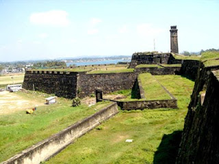 Galle is really a tale of two cities. Inland, to the north of the Colombo-Matara Road, is the modern commercial town characterised by a jumble of bustling stores, warehouses and small restaurants. Here, by the banks of the old Dutch Canal, may be found the railway station, bus station and main bazaar. It's a place to arrive, leave, eat, shop for necessities or change money (though there are also two money-changing facilities within the fort itself). The only building worthy of note is St Mary's Cathedral, built by the British in 1874, and of more interest for the views its provides over the Old Town than for any intrinsic architectural merit. Nevertheless, "New Galle" is the beating commercial heart of the city without which the Old Town would have difficulty surviving, and would lose much of its bucolic charm. Immediately south of the Colombo-Matara Road, and dividing the commercial sector from the old fort, lies an area of open land which, since 1998, has acquired increasing international fame. Once known simply as The Esplanade, it is now graced with the title Galle International Stadium, an international test cricket venue which continues to grow in stature and reputation alongside the remarkable successes of the Sri Lankan national team. Just to the south of the stadium Old Galle begins. Its barriers are unmistakable, as three massive bastions rise up behind the playing field, cutting off the fortified peninsular from the hustle and bustle of commerce -- almost, it might seem, from the 21st century.
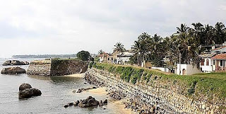 Galle Fort covers an area of 36 hectares and encloses several museums, a clock tower, churches, mosques, a lighthouse and several hundred private dwellings. Tellingly, there are no major Buddhist temples within the walls -- the Dutch may have been gone for more than two centuries, but their cultural influence, best represented by the crumbling Groote Kerk, local seat of the Dutch Reformed Church, remains palpable. It takes a full day to explore Galle Fort properly, but given this length of time the exploration can be carried out in a leisurely and relaxing manner by foot. The ancient walls, dating in large part from the Dutch establishment of the fort in 1663, are largely intact and make a wonderfully evocative circuitous walk around the fort, especially at dusk when the setting sun illumines the historic western ramparts. The City Ramparts: Galle's Dutch defenders feared—mistakenly, as it turned out—assault by land from the Sinhala kings more than the threat by sea from their British cousins. Accordingly, three great ramparts were built at tremendous cost in both labour and treasure to isolate the peninsula from "the mainland". Stretching across the peninsula from west to east, these are the Star Bastion, the Moon Bastion and the Sun Bastion. Rising high above the present-day esplanade, these deep, c
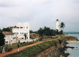 renellated fortifications must once have appeared all-but-impregnable to the armies of Kandy and Colombo. Today, however--and let the visitor be forewarned--their angular crevices provide privacy for courting couples rather than security for archers and musketeers. Quite seriously, one should approach these outer battlements with discretion for fear of giving offence. Towards dusk there is hardly a recess in the battlements without its pair of cuddling teenagers, often shielded from prying eyes behind a large umbrella! It takes about two hours for a leisurely stroll around the walls of the Old City. Only once, between the Aurora Bastion and the Main Gate, is it necessary to descend into the fort itself. Yet this is no great hardship, for nearby is the distinguished New Oriental Hotel, built by the Dutch in 1684 as a governorial mansion, where cold beer, lime soda and other more substantial sustenance are readily available. It's best to make a circuit of the walls clockwise, starting at the New Oriental Hotel. From here it's just a short stroll, beneath great, shady rain trees, to the Aurora Bastion. Continue southwards, with fine views over old Galle Harbour to the east, to reach the 20m-high lighthouse, built by the British in 1934, which dominates Point Utrecht Bastion at the fort's south-eastern corner. The walk continues due west, skirting the Indian Ocean past Triton, Neptune and Clippenburg Bastions -- all, more likely than not, with a few courting couples gazing into the setting sunset. Beyond Clippenburg, as the fortifications turn due north towards Star Bastion and the main northern defences, there is a Sri Lankan Army camp at Aeolus Bastion .
 Inside Galle Fort
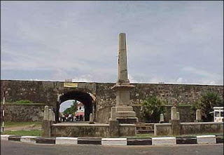
The real charm of Old Galle lies in the quiet back streets and alleyways of the historic fort, which have changed little--if at all -- since colonial times. There are two entries into the fort, the Main Gate, built by the British in 1873 which pierces the main ramparts between the Sun and Moon Bastions, and the more venerable Old Gate, further to the east on Baladaksha Maw (or Customs Road). The latter is distinguished by the British coat of arms carved into its outer stone lintel, while on the inside the initials VOC, flanked by two lions and surmounted by a cock are deeply etched on the inner lintel. This latter inscription is dated 1669, and VOC stands for the Vereenigde Oostindische Compagnie, or United East India Company. The cockerel has become a symbol of Galle, and it is even suggested that the name of the city derives from galo, which is "rooster" in Portuguese. Just beyond the Old Gate stands the Zwart Bastion, or Black Fort--the oldest fortification surviving in Galle, and thought to be of Portuguese origin. With the exception of Zwart Bastion, the interior of Galle Fort is strongly redolent of the Dutch period. Several of the narrow streets still bear Dutch names such as Leyn Baan or "Rope Lane" and Mohrische Kramer Straat or "Street of the Moorish Traders". Beneath the streets an efficient, Dutch-built sewerage system is still flushed out twice daily by the rising tides of the Indian Ocean. Many of the streets are lined with formerly opulent buildings characterised by large rooms, arched verandas and windows protected by heavy, wooden-louvered shutters. The northern part of the fort is dominated by the British-built Clock Tower and a small roundabout located immediately within the Main Gate.
From here Church Street curves away south past the National Cultural Museum (Tue-Sat 9am-5pm; Rs35) with rather poorly displayed exhibits of the city's colonial heritage. The National Maritime Museum on nearby Queen Street (Sun-Thu 9am-5pm; Rs55) is similarly dilapidated, but of more interest than the various fishing and other maritime artefacts is the massively fortified Dutch warehouse in which they are displayed. Old Galle is of much more interest as a "living museum" than for the museums it houses, but it's worth making a quick visit to the Dutch Period Museum on Leyn Baan (daily 8.30am-5.30pm; admission free). This privately-owned establishment houses an astonishing array of Dutch-period artefacts ranging from rare porcelain to obscure bric-a-brac. Of far more interest than the museums is the dilapidated Groot Kerk or Dutch Reformed Church, located--appropriately enough--on Church Street just south of the New Oriental Hotel. Founded in 1754 by the then Dutch Governor of Galle, Capar de Jong, it's in urgent need of restoration but well worth visiting for the ancient Dutch gravestones, both in the churchyard and within the nave. These are generally distinguished by skulls and skeletons, grim reminders of the tenuous nature of life in 18th century Galle, as well as characteristic of the dour nature of contemporary Dutch Protestantism. Opposite the Groot Kerk stands the old Dutch Government House, a fine old colonial building bearing the date 1683 and the cockerel crest of Galle over the main entrance. The original Dutch ovens still survive within the building, which is currently used as a commercial office but slated for redevelopment as a luxury hotel; whether this venture will succeed remains to be seen, as the house is generally believed to be haunted. Further south along Church Street stands the Anglican All Saints Church, built by the British in 1868 and consecrated in 1871. Beyond this, at the southernmost point of the peninsula, a small Moorish community still prospers, with a madrassa or Islamic college and two mosques, the most impressive of which is the Meera Masjid. It's fine to enter, but as with similar Christian, Buddhist and Hindu institutions you should be appropriately dressed and respectful of worshippers.
 Sri Lanka is blessed with over one hundred waterfalls. The tallest is the Bambarakande Falls which cascades down 263 metres like liquid light. It is only four miles away from the Colombo-Bandarawela road in a forest glade, but it is not visited often, though well worth the trip.Bambarakande is taller than the famous Diyaluma falls which is only 220 metres but thought to be the tallest waterfall in Sri Lanka. The Diyaluma or Diya Haluma collects its water from the Poonagala Oya in the vicinity of Koslanda and Wellawaya. Located six miles from Koslanda and 13 miles from Wellawaya, its waters originate from the Mahakande Pass in Koslanda. You can see this waterfall if you stop a while on your way to Haputale and detour.
Due to the geological formation of Sri Lanka, the central highlands are surrounded by peneplains, plateaus and valleys. Rainfall sends a large volume of water hurtling down the precipitous edges of the highland mass. The up thrust millions of years ago has caused several peneplains to form, the highest being well over 6000 ft. It is in this area that the water is collected when there are showers and flows down along tributaries down the mountain slopes.
The Kirindi Oya Falls is the third largest waterfall. It cascades down 200 metres. It can be seen when you go from Ratnapura to Pelmadulla and get on to the Katupitiya road which goes by a tea factory. You have to go along a foot path just beyond the tea factory and if you do not mind the wild grass and reeds, you could go quite close to the waterfall.
 Also along the Ratnapura road, on the Agalawatta crossroad which is very narrow and winding, one can see another beautiful waterfall. The Bopath Falls, a 30 metre fall which descends in three cascades, in the shape of a Bo leaf, is a spectacular sight. It can be seen from afar, from the road opposite the falls. Bathing at the base of the waterfall is fraught with danger as many lives have been lost here. It takes only a three hours drive from Colombo to get there.
When I was in Wales, a waterfall by the exciting name of Devil's Falls was part of our tourist itinerary. After attending a concert and listening to a Welsh girl playing music on a golden harp, we set off to see the waterfall. We had to go a long way to get there and imagine our disappointment when we saw a relatively thin trickle of water. It was nothing like our Dunhinda or Diyaluma which cascades down in torrents. If you happen to go to Venezuela, you could see the highest waterfall in the world. The waterfall is named "Angel" and it has a wonderful drop of 3,200 feet from the edge of the cliff. It comes down in a sheer drop and ends in a mist like froth. The Kukenaam waterfall also in Venezuela falls 2,000 feet. The Niagra is the best known waterfall in the world and thousands of tourists go to see it. In Sri Lanka, though we have wonderful waterfalls of rare scenic beauty, very few people bother to enjoy them.
 Once, friends of mine set off early one morning to see the Duvili Ella waterfall. Most were hazy as to where exactly it was located, only that it was close to Kaltota near the Walawe Ganga. It has been described as one of the most unusual waterfalls in Sri Lanka. The fat, the short, the old, the sprightly and not so agile, all joined the expedition and alighted from the bus with great gusto at Kaltota, 28 km. off Balangoda. The organizer of the trip had made prior arrangements and a soldier with a gun escorted the ladies as it was a politically tumultous time and some were fearful of the forest terrain. Everyone proceeded along a narrow path on the very edge of a precipitous incline.
Finally when the expedition came close to the summit, a huge boulder had to be scaled. And believe it or not, middle-aged sareed ladies were among those who got to the top. No one dared to look down or sideways as the sheer precipice made them dizzy.
Breathless and frightened, they continued their journey till all of a sudden they came to a place opposite the waterfall which fell from a broad rock 40 metres down in a haze of water. It was the most fantastic sight because unlike other waterfalls what you see is a misty cascade of droplets in a sheer veil of shimmering light. That is why it is called Duvili Ella - dust-like waterfall.
There are other waterfalls too like, Baker's Falls in Horton Plains, St. Claire's Falls which we never miss seeing each time we go upcountry by train; waterfalls in unexpected places such as the waterfall in the heart of the Sinharaja forest. A not very well known waterfall is the Ellatota waterfalls near Bandarawela, where we always have a bath holding our heads to the thud of the waterfall and freezing the moment the icy water touched our warm bodies leaving us happy and refreshed.
 Also when staying in Bandarawela, we would visit Ella Rest House and then go to Ravana Ella on the Wellawaya Road. This waterfall is in a very picturesque setting of huge mountains and rolling valleys. The water source is the thick Wewatenna highland. This is connected with Ravana mythology and Sita is said to have bathed here while she was held prisoner by Ravana. The water cascades down in three stages for 9 metres and then meanders along. This is a favourite resting spot for pilgrims who stop off here awhile.
The Dunhinda Falls is in the Uva Highlands in the Veddah country. It is connected with the romantic episode of a Princess Manik Bandara who fled with her commoner lover. They leapt from the top of this waterfall pledging their eternal love. The Dunhinda cascades down in a beautiful stream of water which vaporises as it falls, hence its name.
 The Baker's Falls in the Horton Plains gets its water from the Belihul Oya. It is close to World's End. The icy waters glisten in the sunshine amid a backdrop of mountain terrain and deep valleys and the patna through which you traverse give it contrast. If you are lucky you may see the rare black monkey and rhododendrons in bloom.
Waterfalls will never fail to delight. They are nature's jewels and a natural phenomenon of rare beauty. May they never be destroyed by man in his hurry for development. Picturesque scenic beauty is an integral part of our heritage. A beauty which touches our aesthetic sensibility and transforms our lives
Waterfall in Sri Lanka - Special thank Sirancee Gunawardena
 Sri Lankan architectural tradition is well displayed at Sigiriya, the best preserved city centre in Asia from the first millennium, with its combination of buildings and gardens with their trees, pathways, water gardens, the fusion of symmetrical and asymmetrical elements, use of varying levels and of axial and radial planning.
The Complex consists of the central rock, rising 200 meters above the surrounding plain, and the two rectangular precincts on the east (90 hectares) and the west (40 hectares), surrounded by two moats and three ramparts.
The plan of the city is based on a precise square module. The layout extends outwards from co-ordinates at the centre of the palace complex at the summit, with the eastern and western axis directly aligned to it. The water garden, moats and ramparts are based on an 'echo plan' duplicating the layout and design on either side. This city still displays its skeletal layout and its significant features. 3 km from east to west and 1 km from north to south it displays the grandeur and complexity of urban-planning in 5th century Sri Lanka.
The Rock Citadel
 The most significant feature of the Rock would have been the Lion staircase leading to the palace garden on the summit. Based on the ideas described in some of the graffiti, this Lion staircase could be visualised as a gigantic figure towering majestically against the granite cliff, facing north, bright coloured, and awe-inspiring.
Through the open mouth of the Lion had led the covered staircase built of bricks and timber and a tiled roof. All that remains now are the two colossal paws and a mass of brick masonry that surround the ancient limestone steps and the cuts and groves on the rock face give an idea of the size and shape of the lion figure. Though traces of plaster and pigments occur all over this area, only two pockets of paintings survive.
These are in a depression of the rock face, about a 100 meters above the ground level. These paintings represent the earliest surviving examples of a Sri Lanka school of classical realism, already fully evolved by the 5th century, when these paintings had been made. Earlier the Sigiri style had been considered as belonging to the Central Indian school of Ajanta, but later considered as specifically different from the Ajanta paintings. The ladies depicted in the paintings have been variously identified as Apsaras (heavenly maidens), as ladies of Kasyapas court and as Lightening Princess and Cloud Damsels.
There are also remains of paintings in some of the caves at the foot of the rock. Of special
significance is the painting on the roof of the Cobra Hood Cave. The cave with its unique shape dates from the pre-christian era. The painting combines geometrical shapes and motifs with a free and complex rendering of characteristic volute or whorl motifs. It is nothing less than a masterpiece of expressionist painting
The History of Sigiriya
Sigiriya dates back from over 7,000 years ago, through Pre-Historic to Proto-Historic to Early Historic times, then as a rock-shelter mountain monastery from about the 3rd century BC, with caves prepared and donated by devotees to the sangha.The garden city and the palace was built by Kasyapa 477 - 495 AD. Then after Kasyapa's death it was a monastery complex upto about the 14th century.
The Mahavamsa, the ancient historical record of Sri Lanka, describes King Kasyapa as a parricide, who murdered his father King Dhatusena by walling him up alive and then usurping the throne which rightfully belonged to his brother Mogallana. To escape from the armies of Mogallana, Kasyapa is said to have built his palace on the summit of Sigiriya, but Mogallana finally managed to get to Kasyapa and he committed suicide.
However, there is also another version of the Kasyapa story, related by one of the most eminent historians of Sri Lanka, Prof. Senerat Paranavitana. He claims to have deciphered the story of Sigiry, written by a monk named Ananda in the 15th cent. AD. this work had been inscribed on stone slabs, over which later inscriptions had been written. Till to date no other epigraphist has made a serious attempt to read the interlinear inscriptions.
The two conflicting versions have been the basis for the historical novel Kat Bitha by daya dissanayake, published in 1998. The book won the state literay award for best English novel in 1999
Famous Art - the Sigiriya Frescoes


 John Still in 1907 had observed that; "The whole face of the hill appears to have been a gigantic picture gallery... the largest picture in the world perhaps".The paintings would have covered most of the western face of the rock, covering an area 140 meters long and 40 meters high. There are references in the Graffiti to 500 ladies in these paintings.
The term Mirror Wall is an attempt at  translating the word used by the ancient writers. They used the term Kat Bitha for this wall enclosing a walk or gallery leading up to the Lion Staircase.
Mirror Wall
The term Mirror Wall is an attempt at translating the word used by the ancient writers. They used the term Kat Bitha for this wall enclosing a walk or gallery leading up to the Lion Staircase.kat bitha a historical novel based on Sigiriya, won the the State Literary award for best english novel in 1999.According to the Sigiri Graffity; The lime plaster of the brick masonry wall had been so highly polished, that it had reflected the paintings on the opposite rock wall. Today, fifteen centuries later, the shine on this wall can still be seen
Graffiti
A total of nearly 1500 writings have now been deciphered. The first study and publication was by Prof. Senerat Paranavitana which itself is a masterpiece of the literary, social and creative activities of the period, the earliest recorded poetry found in Sri Lanka.
Since Sigiriya was abandoned after Kasyapa's death, visitors had been attracted to it from around the 6th century till about the 13th century.
They had come to see the paintings and the palace on the summit and the garden below, even as they do today. Inspired by the wonder they saw, they transferred their thoughts into poetry, which they wrote on the Mirror Wall.
Most of these graffiti were addressed to the ladies in the paintings. These writings have been studied in detail by Paranavitana, in his masterpiece "Sigiri Graffiti", describing the people who had written them, their ideas, their way of life and the grammer and style of a period ranging over a span of over eight centuries
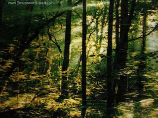 What is SinharajaDense, dark, wet and mysterious - Sinharaja is a primeval forest for meditation, relaxation and for scientific exploration. This relatively undisturbed expanse of primary forest is a Sri Lankan heritage - the last patch of sizeable lowland evergreen Rain Forest still remaining more or intact or undisturbed in our island.
The forest is steeped in deep legend and mystery. The word Sinharaja means, lion (Sinha) king (Raja) and the popular belief it that the legendary origin of the Sinhala people in Sri Lanka is form the descendants of the union the lion king who once lived in the forest and a princess. Today, the spirit of the legend remains captured in solitude in the silent forest and the rising mist of the early dawn. More than time however separates the modern explorer in the Sinharaja forest from its legendary inhabitants, man has rapidly penetrated the seemingly inaccessible wilderness of the Sri Lanka's rainforest which once covered perhaps over
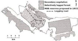
100,000 ha. of the South Western hills and lowlands. The present reserve is but a glimpse of its former glory, occuphying a narrow silver of land 21 km. in length and 3.7 km. in width, covering 11187 ha. of undisturbed and logged forest, scrub and fern land. It was declared an International Man and Biosphere Reserve by UNESCO in 1978, then a National Wilderness Area in 1988 under the National Heritage Site in 1989.
To the casual observer, the forest represents a tropical rain forest with a dense tall stand of trees, steep and rugged hills etched by numerous rocky streams and rivulets. The value of forests such as Sinharaja are well known for their functions as watersheds and store houses of great biological wealth. It is a rich treasure treasure trove of nature with a great diversity of habitats and a vast repository of Sri Lanka's endemic species found no where else in the world. Sinharaja therefore, represents an irreplaceable genepool, a refugia for all those rare and endangered forms of life, both fauna and flora.
Myths and Legends
The links between the Sinharaja Forest and the Sinhala peoples of Sri Lanka are lost in the mists of legend and lore. Both the forest and the people derive their names from the word "Sinha" lion, and according to legend, the race is the result of the union between a King's daughter and a mighty lion who lived in the forest. The Sinharaja Adaviya i.e. forest, therefore lies embedded in the national consciousness of the Sri Lanka people and occupies a special position of importance.
Legend also claims that the forest was royal territory belonging to the ancient Kings (rajas) of the country and in some early colonial records the forest is referred to as the "Rajasinghe Forest". Yet another states that the forest was the last refuge of the lion, no longer found on the island.
Like all myths, these legends do not state the exact boundaries or location of the forest, and the name seems to have been loosely applied to a group of forest that existed in the south-western section of the island, stretching south form Ratnapura and north form Galle. In fact, taken literally, the name may refer more simply to the "king-sized forest" of the Sinhala people, which perhaps reflects the perception that the local communities had of the forest which seemed to have stretched on all sides around them. However, though precise boundaries were not marked in ancient times, it seems very probable that the forest which lies on the route from Galle to the sacred mountain of Adam's Peak was well known and traversed often. In the past, Galle was the premier port of call for foreign ships and travelers. All pilgrims to the Peak
therefore would have disembarked at Galle and made their way through sections of the forest to Ratnapura to begin their ascent of Adam's Peak. Such a journey is in fact described by the famed Arab traveler Ibn Batuta in the 14th century.
Records in History
Proper documentation of the area begins with the Portuguese, the first European power to seize control of the maritime districts of Sri Lanka. During their administration from 1505 to 1656, t he Portuguese carefully compiled lists of villages so that the task of collecting taxes would be made easier. These lists (thombos) contained not merely names but detailed descriptions of the location and extent of each village as well as of the agricultural produce, including timber and fruit trees, fount there. The antiquity of certain village is made manifest in these Portuguese records for modern towns and villages in the Sinharaja region such as Kalawana and Pothupitiya still bear the same name they had when the Portuguese wrote about them four centuries ago.
The next European power, the Dutch, (1656 - 1796) not only took over and maintained these records but also made a more important contribution of charting the area on maps. By 1789, the Sinharaja region had been demarcated on a map that also traced the course of the two large rivers, the Gin Ganga and the Kalu Ganga which had their head waters in the Sinharaja.
Climate
The Sinharaja lies within a rainfall range of 3,000 to 6,000 millimeters. Rainfall figures available for the last 60 years show values ranging from 3,614 to 5,006 millimeters in places, in and around the Sinharaja . The high annual temperature of the Sinharaja is
typical of the tropics, recording little seasonal variation, but with marked daily ranges. The lowest mean monthly
temperature has been abserved during the wettest season and the highest during the driest season. Conventional temperature
Animal
Mammals
In sinharaja, as in any rain forest, the presence of larger mammals is indicated in the form of droppings, tracks, calls ect. The terrain and structure of the forest, however, make visual sightings comparatively difficult.
The Purple-faced leaf Monkey is perhaps the most observable of the mammals. These monkey move in grounds of 10 to 14, high up in forest canopy and their territorial calls echo for ,miles around the forest. The Toque Monkey is rare the forest but is more commonly observed in the peripheral areas.
Several large mammals are characteristically terrestrial and feed off the forest floor. This group includes herbivorous browsers and mixed feeders, such as the Wild Pig, the Sambhur, the Mouse Deer and the Barking Deer. Although Elephants were common in the periphery of the forest before the logging project, they have not been sighted in the western sector since 1974. However, a small group has been reported in the remnant grassland patches of the Handapan-Ella and Thangamali plains which are contiguous with the northeastern part of the forest.
The major carnivore of the forest is the Leopard. Leopards are seldom sighted but their presence is frequently confirmed by tracks and other sings. Genuinely rare are the Rusty-spotted Cat and the Fishing Cat, while in the periphery of the forest.Of the nocturnal species, the two commonly recorded are the civets and the mongooses. Among these are Civet, an endemic species, and the Striped-necked Mongoose. The Sighting of the latter in 1982 was particularly in sinharaja are mainly rats, shrews and squirrels. Several significant sightings have been made in this group. The Bicoloured Rat and the Spiny Rat, both endemic genera, 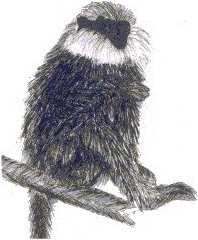 were found here, as were the endemic species of shrews, the Long-tailed Shrew and the Horsefield's Shrew. The
Bi-coloured Rat and the Long-tailed Shrew have been recorded earlier only at elevations of 1,000 meters and above. The records for Sinharaja at 300 to 500 meters show that they have a considerably wider distribution than thought earlier. The
Horsefield's Shrew too had earlier been recorded only in the eastern range of the central hills, hence the sightings at Sinharaja mark the first record of its occurrence in the wet lowlands.
The small mammals in particular formed the focus of quantitative studies carried out in the early 1980's. the results of comparative studies in three different types of habitats, viz. underscored the importance of undisturbed forests for the survival of endemic species. "The Bicoloured Rat, for example, which was predominant in natural sites disappeared at the slightest disturbance. This indicated the high habitat sensitivity of species. On the other hand, the species such as the spiny Rat appeared to be more adaptable and seemed able to exploit natural forest gaps as well as disturbed sites such as logged forest. There is also clear evidence that natural species are beging repidly displaced by aggressive commensals such as the Bandicoot and the Common House Rat.
There species of squirrels are common in the forest, the Flame-striped Jungle Squirrel, the
Dusky-striped Jungle Squirrel and the Western Giant Squirrel. The latter is an arboreal species; so is the Flying Squirrel seen at dusk. Among other mammals recorded in the forest are the Porcupine and the Pangolin.
Bats are a characteristic group of mammals in the Asian tropics. Six species have been recorded in sinharaja, all of which are insectivorous species. It is interesting that the familiar Flying Fox or Fruit Bat has not been recorded in the forest. The only frugivorous species observed, the Short-nosed Fruit Bat has been sighted at Kudawa, on the outskirts of the forest.
Birds
The Sinharaja Reserve is rich in bird life with an impressive 147 species recorded to date. It is also the only locality where 18 out of 20 birds species endemic to Sri Lanka may be viewed.Interestingly, few endemic and other species thought to be confined to the hill-zone have also been sighted at Sinharaja viz. the White-eye, the Scaly Thrush (Zoothera dauma), the
Wood Pigeon (Columba torrigtoni), the Dusky Blue Flycatcher (Muscicapa sordida) and the Yellow-eared Bulbul (Pycnonotus penicillatus). The wide variety of habitat-specific birds seen in Sinharaja is due to the continuous expanse of forest ranging from 300 to 1,500 meters, which provides the habitat of the forest is comparatively better studied than the other groups of animals. These studies include an inventory of the species; more detailed studies on population dynamics, feeding activity and other behavior patterns are currently in progress.
Among the birds recorded in the western sector of the Sinharaja, 13% were migrants. Of the resident species, 18% were confined to the heavily forested areas and 10% to village home-gardens and peripheral scrub areas. At least 36% of the species were common to the forest as well as to outside habitats. This is mainly due to the spread of secondary scrub areas into the forest particularly along logging roads. Data available indicates that most bird species are habitat sensitive and likely to be eliminated if forest areas are disturbed. 56% of the species are either rare or have low population densities. Of the 42% classified as common, a large proportion, 68% were confined to heavily forested undisturbed areas. Meanwhile, the International Council for Birds Preservation (ICBP) world list of threatened bird species for 1989, includes several species found at Sinharaja such as the Blue Magpie, the White-headed Starling, the Ashy-headed Babbler, the Green-billed Coucal, the Red-faced Malkoha, the Spotted-winged Thrush and the Wood Pigeon. Mixed species bird flocks are one of the most interesting experiences of the forest. This peculiar aggregation of birds, is thought to be a strategy for improving feeding efficiency and protection against predators. Observations made on at least 100 such flock at Sinharaja, revel that over 40 species of birds, including 12 endemic species, participate in flocks .
Bird flocks shows a distribution pattern that corresponds closely with the stratified vegetation structure. Different groups of species occupy the forest floor, undergrowth, mid canopy and high canopy. Flocks are also regularly accompanied by animals such as the Giant Squirrel, the Jungle Squirrel, the Purple-faced Leaf Monkey and the Mouse Deer.
Bird ringing has also been carried out regularly at Sinharaja since 1983, mainly to determine the home-range of bird species. So far 164 birds belonging to 32 species have been ringed. This method is also useful for the study of migrant species. In the Sinharaja, three important migrant species have been captured, the Layard's Flycatcher, the
Indian Blue Chat and the Broen Shrike. These were recaptured in the same location during successive year, indicating site specificity of species during migration.
Reptiles
The reptilian fauna of Sinharaja is represented by 45 species, of while 21 are endemic. This includes a large proportion of snakes, several lizards, tortoises and skinks . Among the snakes, two very rare species have been recorded.
These are the burrowing fossorial species Rhinophis tricolorata and Haploceros ceylonensis. Rhinophis was first described as recently as 1975 and was sighted at Sinharaja in 1982, the first time it was found in the wild. Haploceros was considered to be a rare montane species found at elevations of 1,700 to 2,300 meters, until it was recorded in Sinharaja at elevations of 300 to 500 meters
Among the venomous species that occur in the forest are the Green-pitviper while is arboreal, the Hump-nosed Viper and the Krait while frequents the forest floor. The Cobra is seen occasionally while the Russel's Viper has been observed in secondary vegetation, although not seen in the undisturbed forest.
Among the lizards, the commonest is the familiar Green Garden Lizard. Several rare and endemic species of lizards are found in the forest . Among these are Calotes liopepis, an arboreal species while is one of the rarest the island, the Hump-nosed Lizard, the largest lizard in the island; the Earless Lizard and the Rough-nose Horned Lizard are species of the forest floor with very restricted distribution being confined to undisturbed rain forests. A few species of geckos are also common.
The skinks found in the wet-zone of Sri Lanka are of evolutionary significance. The five genera of limbless lizards or the Acintoniae exhibit a progressive series from limbed to limbless forms. The only other centres of distribution of these genera are Madagascar and South Africa. In the Sinharaja, this group is represented by Nessia burtoni or the Three-toed Skink, an endemic genus. However, it is most likely that several more species of unidentified skinks may be present
Amphibians
The rain forest is the habitat parexcellence for amphibians. It is not surprising therefore that half the total number of amphibian species in sri Lanka and nearly half the endemic amphibian are represented in Sinharaja. These amphibians are mainly frogs and toads and a single limbless form
One of the commonest frogs in the forest is the Wrinkled Frog heard frequently from marshes and streams. Several species of tree frogs and the Reed frog while has a call similar to that of a bird can be heard distinctively at night.
The moist environment is conducive for the Sharp-nosed Tree Frog to lay its eggs in a nest of foam on the underside of Cardamom leaves overhanging a stream. This enables the young tadpoles to drop straight into the water when they hatch out. The Lesser Sharpnosed Tree Frog adopts a different strategy. It lays eggs on leaf little where rain water has accumulated. The life cycle is completed within the egg thereby avoiding a free swimming tadpole stage. Others such as Ramnella palmata live their whole life cycle in tree rot holes filled with rain water. The 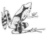 Guenther's Cliff Frog inhabits vertical rock faced covered with dripping water. the young tadpoles are adapted to living on the wet rock face. These strategies among the amphibia could only be possible in an ever-wet environment. The discovery of Guenther's Cliff Frog in 1982 is particularly significant because its sighting at Sinharaja is the first since the type specimen was collected in 1890.
The Yellow-banded Caecilian the only limbless amphibian recorded at Sinharaja, inhabits marshy edges and lives under the wet earth
Fish
The fish show little diversity with only three species commonly occurring in all forest streams. All these
species are endemic to the island. The Comb-tail (Belontia signata) with red tinted fins and tail is found slow moving streams. The Stone-sucker (Garra lamata ceylonensis) is found clinging to rocks where if feeds on moss and the striped loach (Neomachilus notostigma) is found among the leaf little at the bottom of streams.
The Dutch maps made systematic exploration easier during the British colonial period (1796 - 1948) that followed. Under British rule, a number of expeditions were mounted for a variety of purposes. Some, especially the official surveys, were purely commercial in nature. The 1873 exploration by James Gunn, The example was meant to ascertain the suitability of the region for raising coffee plantations and for the possible exploration of its timber resources. On the other hands, George Henry Thwaites in the 1850's was responsible for the first comprehensive documentation of the island's flora in "Enumeratio Plantarum Zelaniae" (1858 -1864) which made numerous references to plants found in the Sinharaja. The most notable of early British explorations of the Sinharaja was that of the soldier-ornithologist, Captain Vincent Legge who incorporated the result of his forays into his work, "The History of the Birds of Ceylon" (1880). In the latter part of the nineteenth century, foresters, botanists and surveyors occasionally visited the flora began to appear in recognized journals. For instance, The forest by Frederick Lewis a forester, appeared in 1896 in "The Ceylon Forester". Further references to plant life in Sinharaja appeared in Henry Trimen's "The Handbook to the Flora of Ceylon" (1893 - 1900).
As far back as 1840, the Sinharaja become Crown Property under the Wasteland Ordinance, Which declared all forest and unoccupied or uncultivated land in the country as crown land. In May 1875, Under an amended ordinance aimed at regulating the felling and removal of timber from land an area of 6,000 acres was declared as the reserved forest of "Sinharaja Mukalana". (Ceylon Government Gazette No. 4046 dated 8th May,1875.)
patterns however change during long periods of drought or excessive rainfall.
Virgin Sinharaja Blog - Special Thank to Asanga Abeywickrama
 Nàga Kings - Chulodara and Mahodara regarding a gem throne. The Bak Full Moon Poya commemorates Buddha's visit to Nagadipa to settle a dispute between Chulodara and Mahodara, two kings belonging to the Naga tribe, over the possession of a gem studded throne.
  It was a battle between uncle and nephew - the uncle being Mahodara and Chulodara, the nephew. Mahodara's sister had married another Naga king and Chulodara was their son. After the death of Chulodara's grandfather the gem studded throne which belonged to him was given to the daughter, Chulodara's mother.
 According to legend, he was a resident of Nagadipa in his previous birth and had provided some Pacceka Buddhas with leaves from a tree to clean their alms bowls. The merit he acquired from that deed had made him a deity.


